Multiscale Segmentation
Extraction Method for Mars Craters

CS 566 Project

Tang Sui, Chen Wei, Qianheng Zhang
University of Wisconsin-Madison

Project Presentation

Introduction

This study investigates extracting Martian impact crater segmentation from high-resolution DEM (HRSC DEM) using three point cloud deep learning networks: PointNet, PointNet++, and RandLA-Net. We focus on segmentation tasks based on point cloud features and multi-scale sampling performance. By comparing these models on a Martian crater point cloud dataset, we explore how different architectures address the unordered nature of point clouds, point correlations, and transformation invariance. This work lays the foundation for future Martian surface classification and landing site selection for Mars rovers.
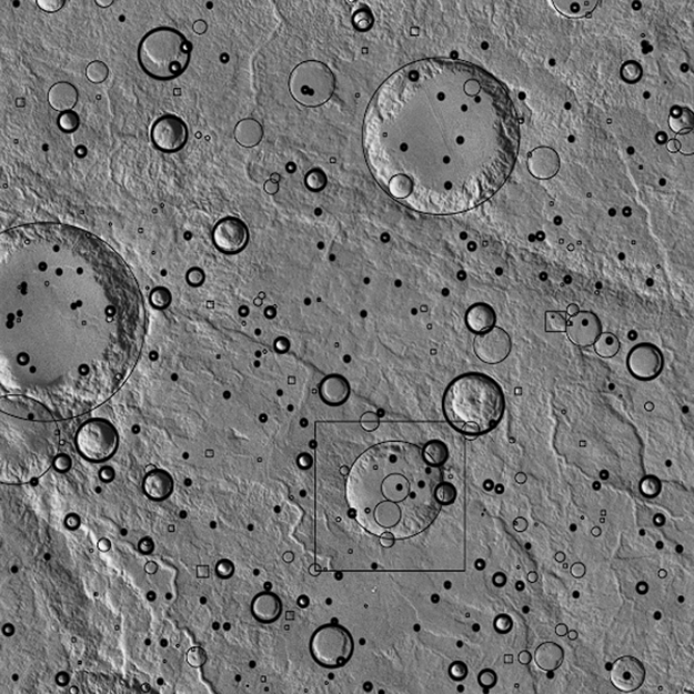
Crater extraction results
Visualization of crater extraction

Identifying and cataloging impact craters is essential for understanding Martian topography and supporting tasks like landing-site selection and geological studies. However, optical imagery has limited high-resolution coverage, and spectral imagery suffers from shadow-induced information loss. To address these limitations, we adopt point-cloud-based semantic segmentation using high-resolution DEM data, which better preserves geometric information and enables broader coverage. Deep learning approaches can extract higher-level features and provide improved accuracy compared to traditional methods.


Characteristics of Martian Impact Craters

Impact craters are formed when celestial bodies collide with planetary surfaces. Martian craters are categorized into four types:

  • Simple craters (<5 km): Bowl-shaped with depth-to-diameter ratio ~0.2
  • Complex craters (>5 km): Contain central peaks and terraced walls
  • Multi-ring basins (>130 km): Concentric mountainous rings
  • Buried craters (>200 km): Found in quasi-circular depressions

Craters on Mars vary drastically in size, number, density, and morphology across different regions. The largest confirmed crater exceeds 2,300 km in diameter and lies in the southern hemisphere, while the smallest craters—only tens of centimeters wide—are ubiquitous.
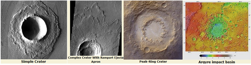
Different types of Martian craters

Data

We use HRSC DEM (100m) data to create a Martian crater point cloud dataset with comprehensive coverage of different crater types and sizes for robust multi-scale evaluation.

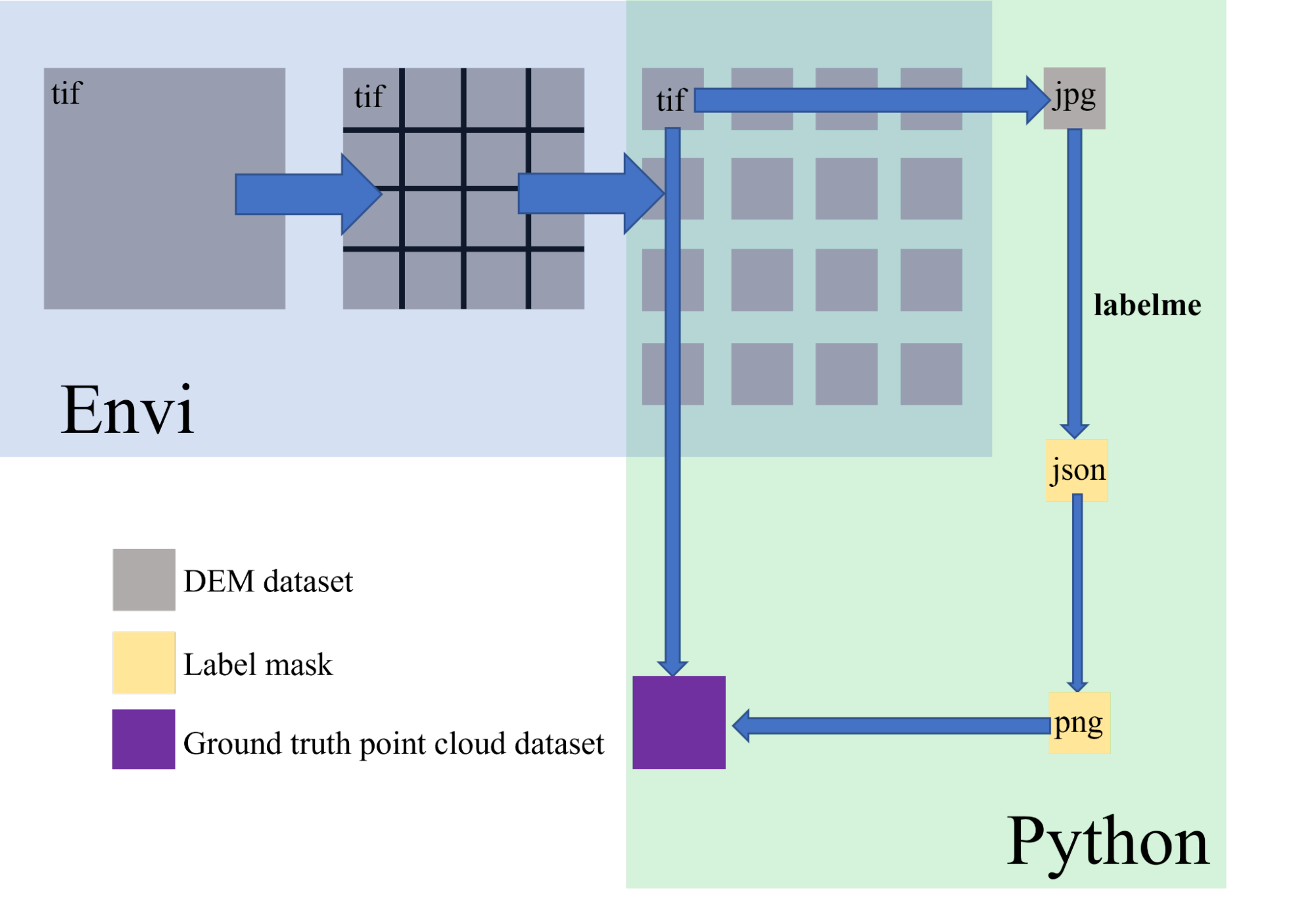
The data preprocessing pipeline consists of the following steps:

  1. We first use the DEM data to create a point cloud, which is saved as the ground truth.
  2. Based on the ground truth, we annotate the craters on the DEM data manually using the labelme tool, and save these as ground truth annotations in JSON format.
  3. We transform the JSON annotations to PNG images, which are saved as the ground truth labels.
  4. The final pair of point cloud and ground truth labels is used for training and testing the point cloud segmentation models.
Data preprocessing pipeline

Methods

We implemented and examined three point cloud networks—PointNet, PointNet++, and RandLA-Net. Focus on the segmentation performance and multi-scale sampling capabilities for handling unordered point data, point correlations, and transformation invariance.

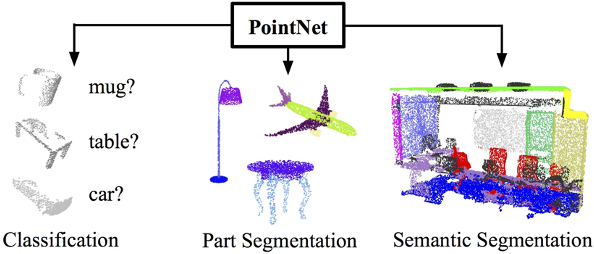
PointNet

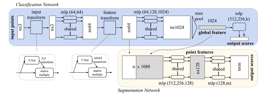
PointNet uses symmetric functions (max pooling) to handle permutation invariance and includes a transformation network for transformation invariance, but lacks explicit multi-scale sampling.

PointNet architecture
Classification and segmentation network overview for PointNet

PointNet++

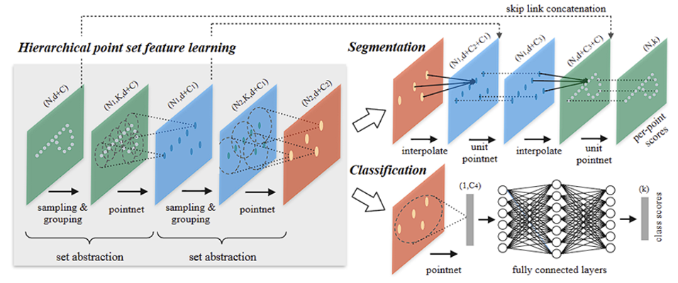
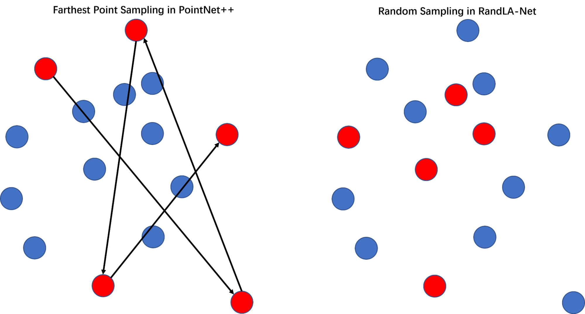
PointNet++ extends PointNet with hierarchical processing, using farthest point sampling (FPS) and grouping to capture multi-scale local structures and fine-grained patterns.

PointNet++ architecture

RandLA-Net

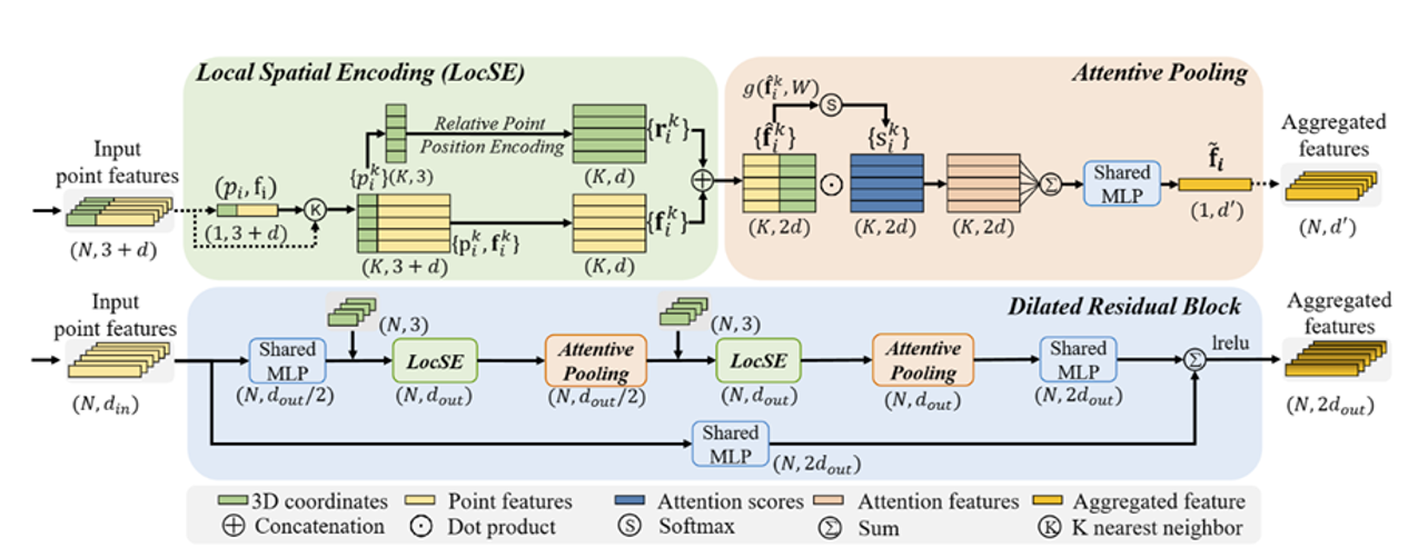
RandLA-Net uses random sampling for efficiency and incorporates local feature aggregation with attention mechanisms to preserve important features during downsampling, making it effective for multi-scale crater segmentation.
The key difference between PointNet++ and RandLA-Net is the local feature aggregation module. The local feature aggregation module in RandLA-Net effectively preserves the complex local spatial structures of large-scale point clouds by explicitly modeling neighboring geometric structures and significantly enlarging the receptive field. At the same time, it is composed only of feed-forward MLPs, thus maintaining good computational efficiency.

RandLA-Net architecture
Sampling strategy comparison
Different sampling strategies between PointNet++ and RandLA-Net

Results

We evaluated the three models on our Martian crater dataset, demonstrating the effectiveness of different architectural choices for multi-scale crater segmentation.

Quantitative Results

Metric PointNet (epoch = 250) PointNet++ (epoch = 250) RandLA-Net (epoch = 150)
Accuracy 0.8869 0.9195 0.9283
Precision 0.7892 0.9042 0.8510
Recall 0.9455 0.8739 0.9247
F1-Score 0.8603 0.8888 0.8828
mIoU 0.7713 0.8147 0.8995
Quantitative comparison (mIoU: mean Intersection over Union)

The quantitative results demonstrate that RandLA-Net outperforms the other models across most metrics, achieving the highest accuracy (0.9283), recall (0.9247), and mean Intersection over Union (mIoU, 0.8995). While PointNet++ attains the best precision (0.9042) and competitive F1-score (0.8888), RandLA-Net's balanced high recall and mIoU indicate superior overall segmentation performance on the dataset. These findings suggest that incorporating advanced architectures like RandLA-Net can significantly enhance crater detection and segmentation from high-resolution DEM data compared to traditional point-based models.

Qualitative Results

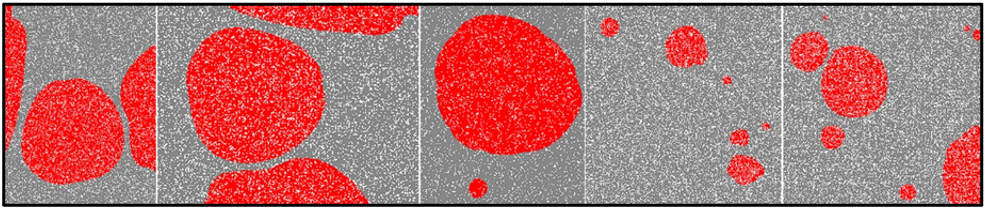
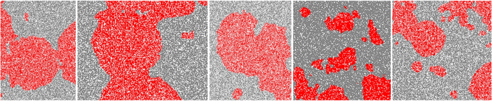
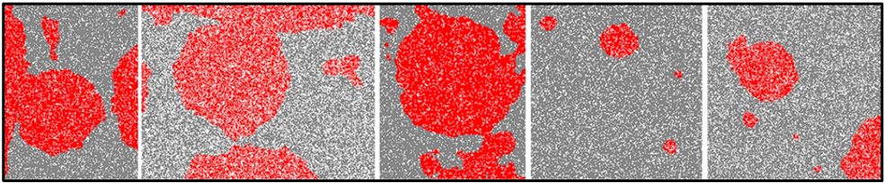
We visualize the model predictions and the ground truth annotations for the three models.

Model Predictions

Ground Truth

Ground truth annotations

PointNet

PointNet results

PointNet++

PointNet++ results

RandLA-Net

RandLA-Net results

We visualize the ground truth annotations alongside the model predictions below.
PointNet struggles with fragmentation—many small craters are missed, and boundaries are fuzzy.
PointNet++ improves overall structure, but still misses finer details.
RandLA-Net produces the closest match to the ground truth—its boundaries are clearer, and it captures both small and large craters effectively.

Key Findings

Multi-scale Performance: RandLA-Net performs best at crater edge extraction due to its local feature aggregation module. PointNet++ outperforms PointNet through hierarchical sampling.

Computational Efficiency: RandLA-Net's random sampling is more efficient than PointNet++'s FPS, which is more efficient than PointNet's approach.

Segmentation Quality: PointNet++ and PointNet tend to misclassify background as craters, while RandLA-Net may miss smaller craters—different strategies suit different application scenarios.

Conclusion

We demonstrate the effectiveness of multi-scale sampling strategies for handling the vast scale variation of Martian craters using three point cloud networks. This work lays the foundation for future Martian surface classification and landing site selection.

Future Directions:

  • Morphological Constraints: Incorporate circular/elliptical boundary constraints to better adapt models to crater shapes.
  • Task-Specific Evaluation: Design class-specific IoU metrics and evaluation criteria for multi-class scenarios.
  • Handling Class Imbalance: Apply targeted loss functions like Focal Loss to address crater area and count imbalances.
  • Attention Mechanisms: Integrate attention mechanisms into PointNet and PointNet++ to improve fine-grained feature capture.

References

[1] HU Y., XIAO J., LIU L., et al. Detection of small impact craters via semantic segmenting lunar point clouds using deep learning network [J]. Remote Sensing, 2021, 13(9): 1826.

[2] DELATTE D. M., CRITES S. T., GUTTENBERG N., et al. Segmentation convolutional neural networks for automatic crater detection on Mars [J]. IEEE Journal of Selected Topics in Applied Earth Observations and Remote Sensing, 2019, 12(8): 2944-2957.

[3] QI C. R., SU H., MO K., et al. PointNet: Deep learning on point sets for 3D classification and segmentation [C]. IEEE Conference on Computer Vision and Pattern Recognition (CVPR), 2017.

[4] QI C. R., YI L., SU H., et al. PointNet++: Deep hierarchical feature learning on point sets in a metric space [J]. Advances in Neural Information Processing Systems (NeurIPS), 2017.

[5] HU Q., YANG B., XIE L., et al. RandLA-Net: Efficient semantic segmentation of large-scale point clouds [C]. IEEE/CVF Conference on Computer Vision and Pattern Recognition (CVPR), 2020.

[6] MELOSH H. J. Impact Cratering: A Geologic Process [J]. New York: Oxford University Press; Oxford: Clarendon Press, 1989.

[7] BARLOW N. G. Crater size-frequency distributions and a revised Martian relative chronology [J]. Icarus, 1988, 75(2): 285-305.

[8] SALAMUNICCAR G., LONCARIC S. Method for crater detection from Martian digital topography data using gradient value/orientation, morphometry, vote analysis, slip tuning, and calibration [J]. IEEE Transactions on Geoscience and Remote Sensing, 2010, 48(5): 2317-2329.